Banning and Mt. San Gorgonio

oe80r

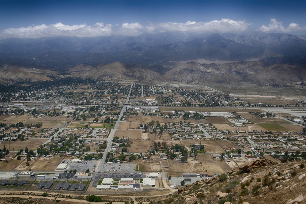
This pic was taken from Highway 243 heading up the mountain toward Idyllwild, looking back down on the town of Banning with Mt. San Gorgonio in clouds in the background.  Mt. San Gorgonio, also known as “Old Greyback”, is the highest mountain in Southern California at 11,502 ft.  Banning was named for Phineas Banning, stagecoach line owner and the “Father of the Port of Los Angeles”.

Ranger Station on Mt. San Jacinto

oe50

This pic shows the ranger check-in station on Mt. San Jacinto, behind the Palm Springs Aerial Tramway terminal station, where long distance hikers headed to area trails register their trips before embarking.  I just stopped by to chat with the ranger on duty, which is always fun and informative.

Links:  previous related post       previous related post


Classic Cars Invade Big Bear Lake

Cars0

A couple of weeks ago we caught just the beginning of the 27th Annual Antique Car Club Fun Run held at Big Bear Lake.  Over 500 classic cars were expected with a highlight of the weekend being a cruise around the lake by everything from restored stock vehicles to wild hot rods.  The pic above shows one of our favorites!

View from Butler Peak Fire Lookout

Tower4

Last week I posted a pic of the Butler Peak Fire Lookout (see link below).  Today I am posting a pic of the awesome view of Big Bear Lake that the Lookout offers.  You can see most of the lake including the airport at the far end.

Links:    Butler Peak Fire Lookout

Jenks Lake

Jenks

Jenks Lake is a beautiful little mountain lake located off Highway 38, twenty eight miles from Big Bear Lake.  Sitting at an altitude of 6,800 ft, it offers fishing from a wooden pier or from shore.  A hiking trail (with picnic tables and restrooms) runs along the parking lot side of the lake.  We want to return and do a little kayaking.

Links:    NFS

Butler Peak Fire Lookout

Tower10

The road to the Butler Peak Fire Lookout (north of Big Bear Lake) reopened to the public in July 2016 after being closed for 9 years.  Sitting at 8,535 feet atop a tangle of rocks, the lookout offers a commanding 360 degree view of the surrounding mountains.  Fire Lookout Host volunteers James and Mark gave us a great overview of its history and function.  Check with the Big Bear Discovery Center to make sure it’s open before you go.

Links:   Fire Lookout Host Program

Converse Basin Grove in Sequoia NP

Stumps

The Converse Basin Grove in Sequoia National Forest was extensively logged in the late 1800’s and many of the stumps are still intact.  The oldest sequoia stump in this area is just over 3,200 years old!

Links:  Sequoia National Forest

Palomar Mountain Roadway

Palomar4

This pic looks back down the roadway leading up to the top of Palomar Mountain.  Camping is available at Doane Valley and Cedar Grove campgrounds in Palomar Mountain State Park and at the Palomar Observatory campground.  Some of the great hiking trails on the mountain boast views of the Pacific Ocean.

Links:   palomarsummit.com    previous related post

Half Dome in Yosemite

Yo10

Half Dome rises 4,737 feet from the valley floor to reach a final height of 8,839 feet. It was first successfully climbed by George A. Anderson in 1875.  Today, the summit can be reached via a 16 mile (round trip) trail, with the last 400 feet being aided by two steel cables.

Links:    Half Dome day hike     previous related post

Acorn Storehouse on Palomar Mountain

Palomar3

This pic shows a so-called “granary” tree on which every crevice has been filled with acorns for later retrieval as a tasty dinner. The industrious storekeeper responsible for this phenomenon is the Acorn Woodpecker.  The largest recorded number of acorns stored in this manner in one tree numbered 50,000.  This tree was in the Palomar Observatory parking lot.